| |
This site traces the use of race restrictive deed covenants in Greater St. Louis in the first half of the twentieth century. It includes interactive maps, background information, and copies of race restrictive deed covenants. |
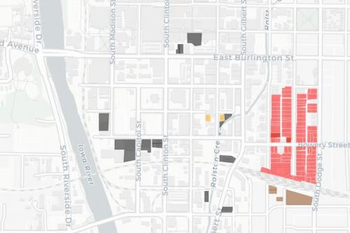 |
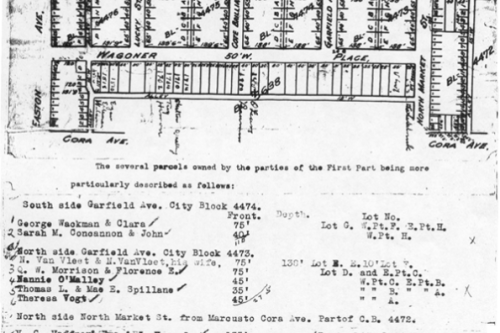
This site traces the use of race restrictive deed covenants in Iowa City /Johnson County and Waterloo / Black Hawk County in the first half of the twentieth century. It includes interactive maps, background information, and copies of race restrictive deed covenants. |
 |
Citizen Brown: Race, Inequality, and Democracy in the St. Louis Suburbs This site is a web companion to the print version of Citizen Brown (Chicago 2019). It includes interactive maps, historical maps and photographs, interactive versions of some of the data visualizations found in the print version, sound clips, video clips, and sources and resources. |
 |
Growing Apart: A Political History of American Inequality This e-book combines historical and economic analysis with interactive graphics to trace the causes--and consequences--of economic inequality in the United States. This project is accessible in two ways: a short version, Our Inequality, was serialized at Dissent in Spring 2014. The full e-book (linked above) is composed in SCALAR, and hosted by inequality.org. It includes a longer (and periodically updated) version of the text and the accompanying graphics. |
 |
This WorldMap project accompanies the book Mapping Decline: St. Louis and the Fate of the American City (PennPress, 2008) It allows users to display or download most of the geospatial data developed for the book. Base layers include both Google Earth and historical maps. |
 |
This web project accompanies Mapping Decline: St. Louis and the Fate of the American City. It presents four interactive series of maps, each touching on a major theme developed in the book. The data available here is not as extensive as on the WorldMap site, but offers a cleaner narrative overview of the history of demographic change, racial restrictions on property, zoning, and urban renewal in Greater St. Louis. |
Data Visualizations
“Unions and Shared Prosperity,” in American Enterprise, Smithsonian (Permanent Exhibit)
"United States, Change in Income 1988-2008," for NPR's Planet Money (August 2014) "Growing Apart: American Income Inequality, 1947-2012," in Andrew Sayer, We Can't Afford the Rich (Polity, forthcoming)
"Unions and Inequality in the OECD," In Richard Wilkinson and Kate Pickett, "Reducing Inequality through Economic Democracy," Progressive Economy Journal (2014)
"HOLC Map of St. Louis, 1943" in Richard Green, The Legacy Of Lending Discrimination Against African-Americans, Forbes (November 2013)
"Unions and Shared Prosperity" (Fig 9, p35) in Sara White, Greener Reality: Jobs, Skills, and Equity in the US Economy (Center on Wisconsin Strategy, 2012)